
IDS GeoRadar Stream DP – Advanced 3D Utility Mapping Maximum Depth Performance
Underground utility mapping is becoming more and more important in infrastructure development, smart city planning, road construction, utility maintenance and archaeological investigations. Today’s underground surveys often require speed, depth and accuracy not achieved by traditional locating methods.
The IDS GeoRadar Stream DP is a state-of-the-art multi-channel 3D GPR designed to provide increased depth penetration and subsurface detection accuracy for underground utility mapping.
The Stream DP is one of the most sophisticated multi-channel Ground Penetrating Radar (GPR) systems on the market today, developed for professionals who need ultra-deep detection, high-resolution imaging and rapid 3D subsurface mapping. Stream DP is powered by IDS GeoRadar’s patented EsT – Equalized Scrambled Technology, which provides unmatched underground detection capabilities, while maintaining exceptional field productivity.
What is IDS GeoRadar Stream DP? .
Underground utility mapping is becoming more and more important in infrastructure development, smart city planning, road construction, utility maintenance and archaeological investigations. Today’s underground surveys often require speed, depth and accuracy not achieved by traditional locating methods.
The IDS GeoRadar Stream DP is a state-of-the-art multi-channel 3D GPR designed to provide increased depth penetration and subsurface detection accuracy for underground utility mapping.
The Stream DP is one of the most sophisticated multi-channel Ground Penetrating Radar (GPR) systems on the market today, developed for professionals who need ultra-deep detection, high-resolution imaging and rapid 3D subsurface mapping. Stream DP is powered by IDS GeoRadar’s patented EsT – Equalized Scrambled Technology, which provides unmatched underground detection capabilities, while maintaining exceptional field productivity.
What is IDS GeoRadar Stream DP?
The Stream DP is an innovative multi-channel GPR array system designed for: • Detection of underground utilities
• 3D sub-surface imaging
• Road/pavement investigations
• Archaeological surveys
• Detection of voids and cavities
• Infrastructure assessment
Stream DP is a novel multi-channel GPR system based on a dense antenna array that provides high resolution underground data acquisition in real-time, thereby allowing to accurately reconstruct buried utilities in three-dimensional space with only one pass.
Revolutionary EsT Technology
The patent is among the key innovations behind the Stream DP:
EsT – Equalized Scrambled Technology
This next-gen tech gets a lot of light on both:
- depth of penetration,
- and resolution of the signal.
Traditional GPR systems usually have a tradeoff between penetration depth and image resolution.
EsT technology provides both deep underground penetration and high-resolution imaging in one system.
Stream DP optimizes the whole radiating performance of the antenna system:
- Improved disturbance rejection,
- Enhanced signal performance by increasing the bandwidth
Increased detection depth
- Simultaneous ultra-high resolution of subsurface imaging
This allows surveyors to identify:
- utilities buried deep
• It gives more clarity and accuracy on the exact location of small utilities, voids and complex underground structures.
Massive Multi-Channel Antenna Array
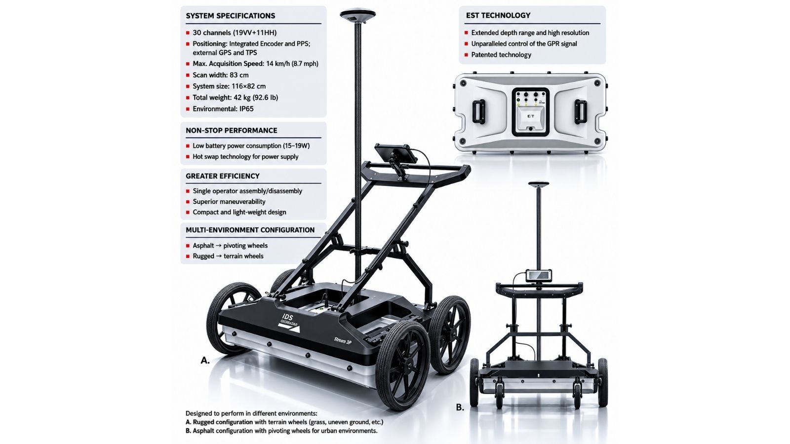
The Stream DP has an advanced:
30-channel dual-polarized antenna array
Configuration:
- 19VV channels
- 11HH channels
Dense array architecture allows:
- High speed data acquisition,
- Full area scanning,
- Accurate 3D utility reconstruction
- Improved underground coverage in one scan.
In comparison to conventional single-line GPR systems, Stream DP offers more comprehensive and consistent collection of subsurface data, reducing gaps and missed utilities in the survey and, consequently, the need for repeat inspections.
Superior Depth Performance
Superior Depth Performance
Maximum underground penetration depth
According to IDS GeoRadar, the Stream DP offers:
Greater depth of detection compared to competing products available.
This renders it very efficient at:
- deep utility corridors,
- large infrastructure constructions,
- tunnel investigations,
- underground tanks,
- as well as subsurface cavity detection.
Its advanced signal processing technology also increases the efficiency of detection of:
- Plastic pipelines,
- Non-metallic utilities,
- Fiber optic cables, and
- other hard-to-detect underground objects.
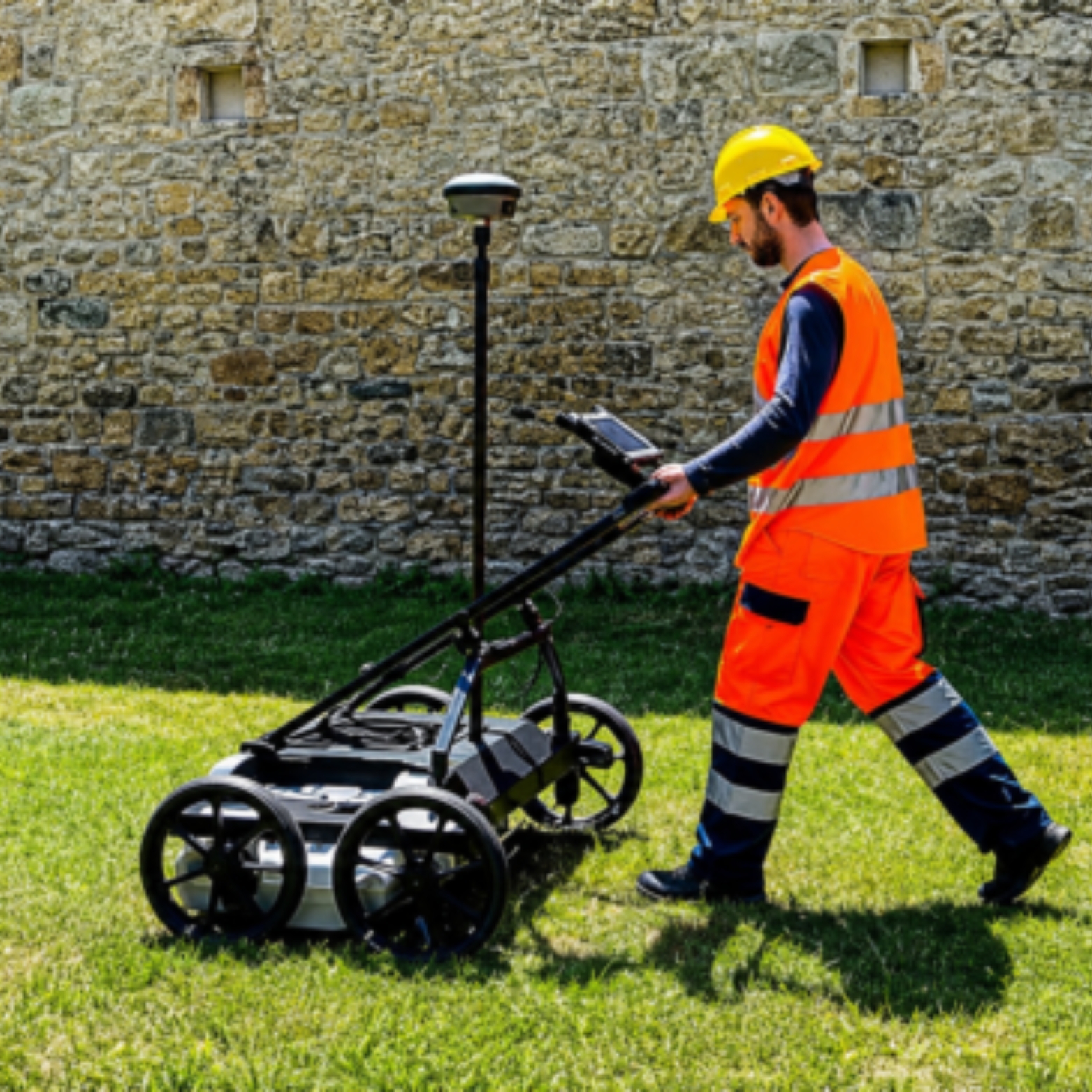
Fast Deployment and Single-Operator Efficiency
One of the strong sides of Stream DP is its high field productivity.
Stream DP possesses ergonomic design and includes lightweight and compact modular parts that allow quick installation.
Main advantages of operation consist of quick setup (5 minutes maximum), one-operator operation, transportation in a regular car and weight of modular parts not exceeding 20 kg.
It increases operational efficiency due to reduction of personnel required, reduction of installation time, simplified transportation and cost of surveys
Asphalt and Rugged Terrain Configurations
Stream DP has been developed to function efficiently in various conditions.
It provides:
- Dual configurations
- Asphalt configuration with swivel wheels
- Rugged terrains configuration
This makes it possible to perform surveys in:
- road cities,
- highways,
- construction sites,
- uneven terrains,
- industry sites,
- and fields.
Non-Stop Surveying Performance
Stream DP has been developed to be used for long-term surveys where energy consumption is crucial, and the equipment requires very little power usage (15-19 W) with hot swap batteries for uninterrupted performance.
This provides non-stop survey performance, because it gives you the possibility of changing the batteries without stopping the survey process.
In case of large utility mapping surveys, this option provides more efficient performance in the field.
Precision Positioning with PPS GPS Synchronization
Positioning accuracy is key in underground surveying.
Stream DP features:
PPS – Pulse Per Second synchronization
It provides accurate synchronization between:
- GPR antenna array,
- And GPS positioning systems.
The outcome of that includes:
- Precision in georeferencing the underground survey results,
- Good alignment,
- And improved mapping.
That is especially relevant for:
- GIS applications,
- CAD projects,
- BIM processes,
- And documentation.
Intelligent Software Ecosystem
The stream DP process relies on the state-of-the-art software package offered by IDS GeoRadar that includes the following:
uMap
A software solution that enables field acquisition for:
- real-time data collection,
- navigation,
- and diagnostics on site.
IQMaps
A sophisticated software solution for:
- data analysis,
- utility evaluation, and
- 3D visualization.
AiMaps 2.0
An intelligent software solution that utilizes artificial intelligence to facilitate:
- simpler utility evaluation,
- improved productivity, and
- faster decision making.
Applications of IDS GeoRadar Stream DP
- The Stream DP is suitable for many different applications and industries:
Utility Mapping
- Water pipes
- Gas lines
- Electrical piping
- Fiber optics
- Sewage infrastructure
Civil Engineering
- Roadways
- Infrastructure studies
- Smart City analysis
Construction
- Pre-construction site studies
- Interference checking
- Underground risk assessment
Archaeology/Heritage
- Buried structure investigation
- Historical site investigation
Geotechnical Surveys
- Void analysis
- Anomaly detection in subsurface area
- Underground voids
Key Advantages of Stream DP
Most Efficient Detection of Utilities
Patented EsT technology adds value through deeper detection while ensuring resolution of data is not compromised.
Fast 3D Mapping
A huge multi-channel array ensures data capturing for the entire underground structure within one pass.
Lightweight & Portable
Its compact design makes it portable and very convenient for use in field work.
Efficiency of Single Operator
It makes operations on site very efficient because it involves minimal manual intervention.
Advanced Data Processing
AiMaps 2.0 software increases efficiency through fast data analysis and improved utility detection.
Why Professionals Choose IDS GeoRadar Stream DP
- This is because it can provide a great competitive advantage due to the accurate detection of buried utilities that have been located in deep soil.
- The Stream DP combines advanced technological capacity, software, and efficient operation on one device, making it possible to gather data more accurately and quickly.
- This product is capable of performing optimally in all aspects for companies involved in underground surveying projects.
- Safe excavation planning,
- The result is less damage to utilities, increased efficiency, and better intelligence.
Conclusion
With its unique qualities such as penetrating EsT signal processing, high density multichannel 3D data acquisition, artificial intelligence-based automatic interpretation, and quick set-up by one operator, the IDS GeoRadar Stream DP system is quite exceptional.