
How Multi channel GPR is Revolutionizing Underground Mapping for Large Area subsurface investigation.
It is important to understand what lies underground before the construction. Hidden Buried Utilities can highly impact project’s timeline and budget of the project. It is very hard to find what lies underground for a large area with traditional investigation methods. As this becomes more complex, Engineering firms and utility companies are moving to advanced multichannel Ground Penetrating Radar (GPR) technology for fast and accurate underground mapping.
What is the Growing Challenge of Underground Asset Detection?
To Reduce the uncertainty for a project it is important to know the proper subsurface information. Unknown utility networks, buried tanks and structures, Underground cavities and voids, archaeological remains, Geological anomalies, Incomplete utility records are the common challenges. Costly redesigns and project delays can be caused by encountering these obstacles.
Why Traditional Survey Methods Are No Longer Enough?
Traditional underground investigation methods rely on Manual utility locating, Electromagnetic detection, Single channel GPR systems and Trial trenching and excavation. These methods can be effective for smaller projects, but this becomes inefficient; we need complete coverage for large survey areas. Higher project costs, incomplete subsurface visualizations, increased labor requirements, limited coverage per survey pass and slow data acquisition are the limitations caused by these methods. So Large projects need a faster and better solution.
What Is Multi-Channel Ground Penetrating Radar?
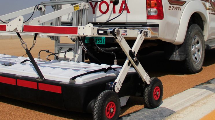
Multichannel GPR uses many antennas operating at the same time which helps to capture maximum subsurface information in a large survey area. This feature helps multichannel GPR to collect more data in less time unlike old single channel systems. Detailed Three dimensional views of underground conditions are provided by this feature. Advanced vehicle towed systems can survey large areas efficiently while maintaining high resolution imaging and accurate positioning. Modern systems can cover an area of 2-meter-wide area in a single pass, increasing survey productivity.
What are the Benefits of Large-scale 3D Underground Mapping
Faster Survey Completion
Multi channel GPR Systems can maximize field productivity by collecting maximum data across multiple channels at the same time. This feature of Multi-channel GPR System helps the survey teams to Cover large areas rapidly, reduce field time, minimize traffic disruptions and improve project efficiency. Under suitable conditions, some advanced systems can survey up to one hectare of land under one hour.
Enhanced Data Resolution
Multichannel GPR improve underground imaging quality with the help of several antenna arrays. Advanced GPR Systems has benefits including Better target detection, Clearer anomaly identification, improved object recognition and detailed subsurface interpretation. These systems incorporate with up to 48 channels with antenna spacing less than 4 cm, which helps to provide high underground resolution.
Accurate 3D Visualization
Ability to generate detailed 3D tomographic models is one of the major advancement in GPR Technology. 3D Visualization allows users to identify buried structures, analyze subsurface anomalies, Map cavities and voids and understand complex underground environments. This level of 3D visualization helps the organization to increase confidence during planning and construction.
Reduced Investigation Costs
By collecting more information in very less survey time, organizations can reduce labor costs, Field deployment time, Excavation risks and Rework Expenses. This helps to generate more ROI to the owners compared to traditional methods.
Applications of Multi-Channel GPR Technology
Utility Mapping and Subsurface Utility Engineering (SUE)
Water pipelines, Sewer networks, Electrical cables, Telecommunications infrastructure, Gas pipelines are located by Engineering consultants using Modern GPR Systems. Chance of Utility is reduced by precise utility mapping.
Archaeological Investigations
Large archaeological sites require non invasive survey methods capable of identifying buried utilities without excavation. Multichannel GPR can reveal Ancient walls, Foundations, Buried Structures and Historical settlement layouts. While preserving cultural heritage, this allows archaeologists to investigate extensive sites efficiently.
Cavity and Void Detection
Having Voids under the infrastructure projects can cause major risk. Advanced GPR technology can help in various Void Detection like Sinkhole investigation, Tunnel detection, Void Mapping, Ground Stability Assessments. Early identification helps to take safety risks and prevent costly failures.
Large scale GPR surveys help identify:
• Buried tanks
• Unknown structures
• Utility conflicts
• Potential hazards
All this information can help organizations to build more safer projects.
The Importance of Integrated Software and Positioning
Modern Underground Mapping is not only about data collection.
Advanced software platforms now provide:
• Real-time target visualization
• GPS-guided navigation
• Survey planning tools
• 2D and 3D tomography
• CAD and GIS integration
Above mentioned capabilities help survey teams to visualize underground conditions in real time and seamlessly transfer results into engineering at the same time.
Things before selecting a large area GPR Solution:
- Survey coverage capabilities
• Number of antenna channels
• Data resolution
• Positioning accuracy
• Software integration
• CAD and GIS compatibility
• Productivity requirements
• Environmental operating conditions
The ideal solution should balance speed, accuracy, and ease of data interpretation while supporting the specific objectives of the project.
Conclusions:
Having correct subsurface information has become essential as the infrastructure development continues to grow rapidly. Professional investigation of the underground environment is transforming with Multichannel Ground Penetrating Radar Technology across engineers and utility owners. By combining features like high speed data acquisition, dense antenna arrays, advanced 3D Visualization, seamless software integration, modern GPR solutions provide a faster, safer and more reliable approach to underground mapping. Large scale 3D GPR technology represents the future of subsurface investigation for organizations responsible for utility detection, archaeological investigations, cavity mapping or construction planning.