

Ground Penetrating radar for real time underground utility
GROUND PENETRATING RADARS
IDS Geo Radar | Stream DP
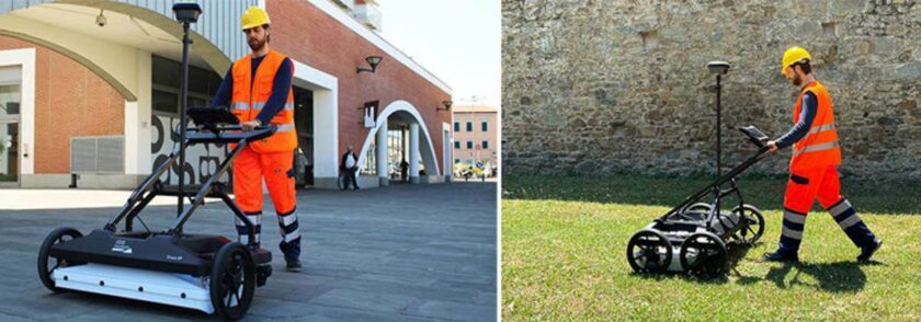
Advanced Multichannel GPR System for Real-Time 3D Underground Utility Mapping
Stream DP is a revolutionary multichannel GPR array solution designed for real-time 3D mapping of underground utilities and subsurface features, setting a new benchmark in underground surveying technology. Powered by the innovative Equalized Scrambled Technology (EsT) developed by IDS GeoRadar, Stream DP takes underground utility detection to an entirely new level by delivering deeper penetration, superior resolution, and exceptional performance in complex environments.
This advanced ground penetrating radar system maximizes underground asset detection capabilities, offering greater depth range and imaging quality compared to conventional solutions available on the market.
Compact, ergonomic and built for efficient field operations
Designed with operator comfort and practicality in mind, Stream DP features a lightweight and ergonomic structure that allows easy handling, transportation, and deployment. With a maximum weight of only 20 kg per component and compact dimensions of 116 cm × 82 cm, the system can be transported using a standard vehicle and assembled quickly by a single operator.
Stream DP is part of the advanced Stream family from IDS GeoRadar, developed to provide high-performance solutions for professional underground utility investigations. Other products in the Stream family include Stream T, Stream UP, and Stream X.
Benefits of Stream DP
AiMaps 2.0 Intelligent Processing Platform
The upgraded AiMaps 2.0 platform uses Artificial Intelligence to simplify underground utility detection, interpretation, and data analysis. This advanced cloud-based solution enhances GPR technology workflows by providing faster processing, improved accuracy, and efficient management of Ground Penetrating Radar survey data.
Revolutionary EsT Technology
Powered by IDS GeoRadar’s patented Equalized Scrambled Technology (EsT), Stream DP delivers exceptional control over GPR signal transmission for deeper underground utility detection, ultra-high-resolution imaging, and superior target clarity. This advanced GPR equipment provides reliable performance for complex utility mapping and subsurface investigations.
High Productivity Utility Detection GPR
Stream DP features a massive multichannel antenna array with 30 channels in dual polarization (19VV + 11HH), enabling fast and accurate 3D reconstruction of underground utility networks in a single scan. The system is ideal for large-scale underground utility detection, pipeline mapping, and infrastructure survey projects.
Greater Field Efficiency
Designed as a lightweight and modular GPR machine, Stream DP can be assembled by a single operator in less than five minutes and transported easily using a standard vehicle. This compact design improves operational efficiency while reducing setup time in the field.
Non-Stop Survey Performance
Low power consumption between 15W and 19W combined with hot-swap battery technology allows uninterrupted GPR scanning and underground mapping operations, maximizing productivity during utility detection surveys.
User-Configurable GPR System
Stream DP is a flexible Ground Penetrating Radar solution that can be configured for different environments and survey applications. Both rugged terrain and asphalt versions are available to support diverse underground utility detection requirements.
Remote Diagnostics Functionality
The cloud-based remote diagnostics system enables technical support teams to access device information directly from the field, improving troubleshooting efficiency, reducing downtime, and ensuring continuous performance of the GPR equipment during critical survey operations.
IQMaps is IDS GeoRadar’s software application for advanced GPR data analysis, which provides a fast interfacing between the user and the GPR data. Machine time is reduced and real-time processing and 3D visualisation are available for advanced target management. IQMaps is the right post-processing solution for utility mapping, archaeological and environmental surveys and extensive mapping of large size projects.
In addition to underground assets detection and mapping, other functionalities are available for 3D mapping of sinkholes, inspection chambers and archaeological sites. IQMaps provides a step by step approach to guide the user in performing the best and the quickest data analysis with the help of a customisable processing and analysis tool, both for skilled and non-skilled users.
IQMaps is available for Stream UP, Stream DP, Stream X, Chaser XR, Opera XR, RIS MF Hi-Mod and Leica DSX, DS4000.
FEATURES AND BENEFITS
- Revolutionary interface
Allows an immersive reality during post-processing phase - Large areas acquisition
There is no limit in software use even for acquisition of large areas - User friendly
Ease of use and productivity have been dramatically increased (up to 30.000 sqm in a working day) - Georeferenced data
The new software has been developed with the precise aim to elaborate a georeferenced data after that it has been processed - Data easy to be managed
Intuitive interface with data ease to use and to be managed (scroll, pinch, spread) - Easy data extraction of various subsoil features
Anomaly detection (sinkholes, substations, buried objects) - Cloud Software Integration
Export, store, share and access data on major Cloud service providers for a streamlined workflow in utility detection
Our Address
Dubai Office
Falcon Geomatics LLC
Ahammed Kamal Warehouse 6
Street 10C
Ras al Khor Industrial 1, Dubai
United Arab Emirates

Abu Dhabi Office
Falcon Geomatics LLC – Abu Dhabi
Musaffah Industrial Area M40
Plot Number 6 & Building 3
First Floor, Office No. 11 & 12
Abu Dhabi
United Arab Emirates
Quick Contact
Copyright © 2026, Falcon Geomatics LLC – All Rights Reserved.